India has achieved another milestone in space technology with the successful launch of NVS-03, strengthening its indigenous satellite navigation system, NavIC. Prime Minister Narendra Modi congratulated ISRO scientists and engineers, describing the mission as an important step towards technological self-reliance and stronger navigation capabilities.
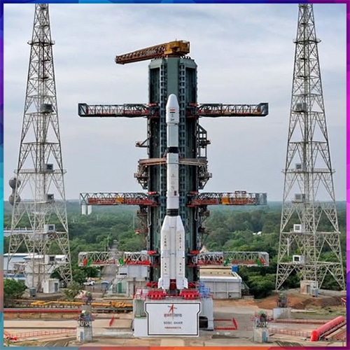
The GSLV-F18 rocket lifted off from the Satish Dhawan Space Centre, Sriharikota, on October 30, 2026, successfully placing the 2,250-kg navigation satellite into its intended Geosynchronous Transfer Orbit. The mission represents the twentieth flight of India's Geosynchronous Satellite Launch Vehicle.
NVS-03 is the third satellite in India's five-satellite next-generation navigation programme. Its deployment is expected to strengthen NavIC's reliability, positioning accuracy and operational continuity, reducing dependence on foreign navigation systems, particularly America's GPS.
A significant technological achievement is the integration of an indigenously developed atomic clock alongside procured clocks. Precise timing is essential for satellite navigation, telecommunications, banking transactions, transportation networks and defence applications.
Key Highlights
-
Successful launch: GSLV-F18 carried NVS-03 into its intended transfer orbit on October 30, 2026.
-
Indigenous navigation: The mission strengthens NavIC, India's regional alternative to GPS.
-
Advanced atomic clock: Indian-developed timing technology supports more independent navigation capabilities.
-
Enhanced compatibility: L1, L5 and S-band signals support a broader range of navigation applications.
-
Regional coverage: NavIC serves India and approximately 1,500 kilometres beyond its borders.
-
Strategic independence: Stronger navigation infrastructure supports defence, transportation, telecommunications and disaster response.
-
Next milestone: NVS-04 and NVS-05 are planned to strengthen the constellation further, while commercial adoption remains essential.
The satellite supports L1, L5 and S-band navigation signals, improving compatibility with modern navigation receivers. NavIC is designed to serve India and areas extending approximately 1,500 kilometres beyond its geographical boundaries, supporting civilian and strategic requirements.
Beyond technological achievement, the mission carries major geopolitical significance. Independent navigation infrastructure strengthens national security, military coordination, maritime operations, disaster management and critical infrastructure resilience. It also creates opportunities for Indian electronics manufacturers, automotive companies and navigation technology developers.
However, successful launch alone does not guarantee complete operational readiness. Further orbital manoeuvres, satellite commissioning and widespread receiver adoption remain important. India's next challenge is transforming NavIC from strategic infrastructure into a commercially scalable navigation ecosystem, strengthening digital sovereignty while supporting innovation across industries.