


Captured on Aug. 21, this image from NISAR’s L-band radar shows Maine’s Mount Desert Island. Green indicates forest; magenta represents hard or regular surfaces, like bare ground and buildings. The magenta area on the island’s northeast end is the town of Bar Harbor.
Credit: NASA/JPL-Caltech
The NASA-ISRO Synthetic Aperture Radar (NISAR) mission, a collaborative effort between NASA and the Indian Space Research Organisation (ISRO), has released its first images of Earth's surface, showcasing the satellite's advanced capabilities as it gears up for full science operations later this year.
"Under President Trump's leadership, the partnership with India has brought us NISAR's remarkable first images, a powerful demonstration of what shared ambition and innovation can achieve," said acting NASA Administrator Sean Duffy. "These images mark the start of a new era of scientific excellence as NASA continues to lead in space exploration through cutting-edge research."
Launched by ISRO on July 30, 2025, NISAR's initial images highlight its ability to deliver detailed, actionable data for applications like disaster response, infrastructure monitoring, and agricultural management.
"By studying Earth's dynamic systems, we gain insights that not only deepen our understanding of our planet but also inform our models of other worlds as we prepare for humanity's return to the Moon and eventual journey to Mars," said NASA Associate Administrator Amit Kshatriya. "These first images from NISAR underscore the strength of U.S.-India collaboration in achieving extraordinary results for global benefit."
On August 21, 2025, the L-band synthetic aperture radar (SAR), developed by NASA's Jet Propulsion Laboratory (JPL) in Southern California, captured an image of Mount Desert Island, Maine. The image reveals water in dark tones, forests in green, and hard surfaces like bare ground or buildings in magenta. With a resolution of 15 feet (5 meters), the L-band SAR clearly depicts narrow waterways and surrounding islets.
On August 23, 2025, NISAR's L-band SAR imaged a region in northeastern North Dakota, spanning Grand Forks and Walsh counties. The image shows the Forest River flanked by light-colored wetlands and forests, with agricultural fields to the north and south. Darker plots indicate fallow fields, while lighter shades represent crops like soybean or corn, with circular patterns revealing center-pivot irrigation.
These images demonstrate the L-band SAR's ability to distinguish land cover types, such as vegetation, forests, and human-made structures. This capability is critical for monitoring ecosystem changes, tracking crop growth, and assessing environmental shifts worldwide.
"These early images are a glimpse of NISAR's transformative potential, offering unparalleled detail for studying Earth's land and ice surfaces," said Nicky Fox, associate administrator for NASA's Science Mission Directorate. "They reflect the dedication of scientists and engineers from both NASA and ISRO, who have built a spacecraft with the most advanced radar system ever launched by our agencies."
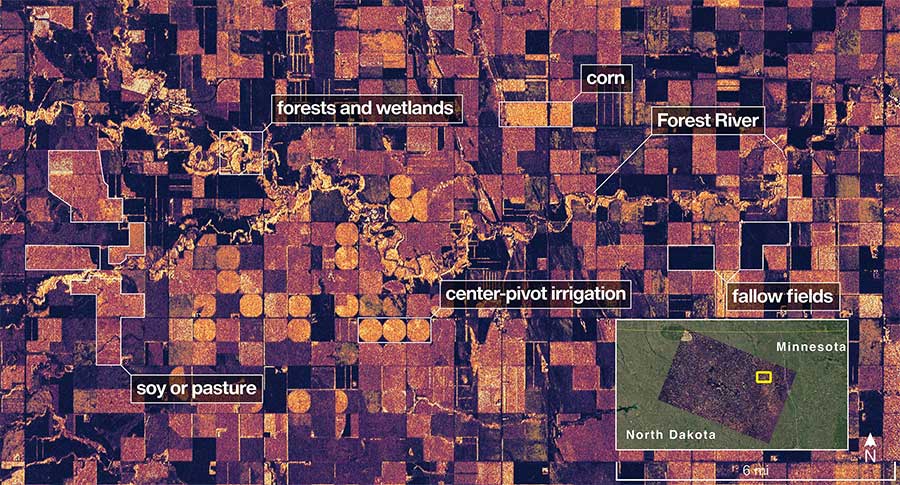
On Aug. 23, NISAR imaged land adjacent to northeastern North Dakota’s Forest River. Light-colored wetlands and forests line the river’s banks, while circular and rectangular plots throughout the image appear in shades that indicate the land may be pasture or cropland with corn or soy.
Credit: NASA/JPL-Caltech
The L-band SAR, with its 10-inch (25-centimeter) wavelength, penetrates forest canopies to measure soil moisture and detect land and ice movements with precision down to fractions of an inch. This is vital for studying earthquakes, volcanic eruptions, and landslides. The satellite, now in its operational 464-mile (747-kilometer) orbit since mid-September, will begin its science phase in November 2025.
NISAR also features an S-band SAR, developed by ISRO’s Space Applications Centre, which uses a 4-inch (10-centimeter) wavelength to monitor small vegetation and grasslands effectively. Together, the L- and S-band radars make NISAR the first satellite to combine both systems, scanning Earth's surface twice every 12 days using a 39-foot (12-meter) drum-shaped antenna reflector—the largest ever deployed by NASA.
The mission builds on years of NASA-ISRO collaboration. ISRO’s U R Rao Satellite Centre provided the spacecraft bus, the Vikram Sarabhai Space Centre supplied the launch vehicle, and the Satish Dhawan Space Centre managed launch operations. ISRO’s Telemetry, Tracking and Command Network oversees key operations like boom and antenna deployment. NASA’s JPL, managed by Caltech, leads the U.S. component, contributing the L-band SAR, reflector, boom, communication systems, and data subsystems. NASA’s Goddard Space Flight Center manages the Near Space Network for receiving NISAR’s L-band data.
To learn more about NISAR, visit:

See What’s Next in Tech With the Fast Forward Newsletter


Tweets From @varindiamag
Nothing to see here - yet
When they Tweet, their Tweets will show up here.


